- WICKNELL CHIVAYO left school at 15
- DISGRUNTLED Zimbabwe police stage uniform protest.
- MNANGAGWA wife Auxillia drops charges against nine women who boed her in Manicaland
- O.J. Simpson dies of cancer , aged 76.
- South Africa ANC is the cause of ZIMBABWE troubles claims Zimbabwe opposition politician Job Sikhala
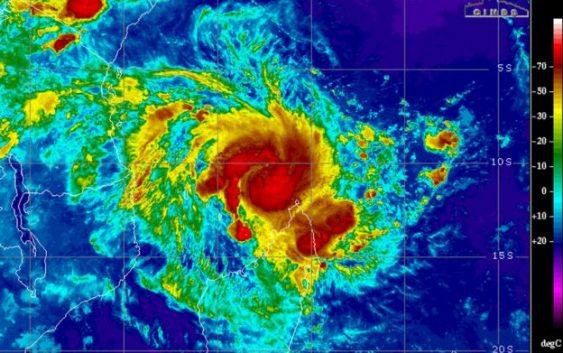
Cyclone Kenneth (200km/h (124 mph) follows the deadliest storm to strike Mozambique in 3 decades, cyclone IDAI which killed 700 people
A new tropical threat in the southern Indian Ocean may bring life-threatening weather to parts of Mozambique and Tanzania later this week.
Kenneth underwent additional strengthening on Wednesday and Wednesday night and has been upgraded to an intense tropical cyclone by Meteo France, the French national meteorological service.
An intense tropical cyclone contains sustained winds of 159-209 km/h (99-130 mph), which is equal to a hurricane of Category 3 to 4 strength in the Atlantic or East Pacific oceans.
Prior to reaching the eastern Africa coastline, Kenneth brought heavy rainfall to parts of Madagascar from Monday into Wednesday.
Locations from Ambanja and Antisiranana to Andapa and Antalaha had drenching downpours and localized flooding. Rainfall totals of 50-100 mm (2-4 inches) were common with 300 mm (12 inches) reported in Sambava.
Downpours and strong winds lashed Mayotte Tuesday night into Wednesday. Additional downpours and strong winds are expected to last into Thursday morning as Kenneth passes north of the island.
Comoros will be the next location at risk for significant impacts from Kenneth. While rain and occasional gusty winds reached the islands on Wednesday, the worst of the storm is yet to come.
Comoros will endure a period of stormy weather with the potential for a direct hit on Grande Comore. Kenneth will continue to strengthen as it passes over or just north of the island into Thursday, bringing 100-200 mm (4-8 inches) of rainfall and damaging winds. Wind gusts up to 195 km/h (120 mph) will be possible across the island.
Damaging winds and flooding rainfall will be possible across the rest of the islands of Comoros into Thursday.
Dangerous seas will batter the island’s coastal locations through the day on Thursday, causing coastal flooding and creating life-threatening conditions for marine operators.
A storm surge of 2-4 meters (6.5-13 feet) may occur near and just south of where Kenneth makes landfall. This surge, combined with tides and rough surf, can lead to life-threatening flooding.
Cyclone Idai was the deadliest storm to strike Mozambique in at least 3 decades
Further strengthening is possible during the day on Thursday as the storm approaches the southern coast of Tanzania and northern coast of Mozambique.
Downpours will continue to increase in coverage and duration into Thursday.
At this time, landfall of Kenneth could occur as early as midday Thursday near the border of Tanzania and Mozambique. If Kenneth tracks slower and has more time to strengthen, landfall may not occur until Thursday night.
Areas near and just inland of this landfall location will be at risk for flooding rainfall, mudslides and damaging winds.
Locations from Lindi, Tanzania; to Pemba, Mozambique; are most likely to experience the worst of this storm.
“At least 700,000 people are at risk within the region of Cabo Delgado if this storm makes landfall as forecasted,” said Marc Nosbach, CARE Mozambique’s country director.
“Aside from storm damage, the greatest risk will immediately be from flooding due to heavy rains. Rivers within this region of Mozambique may flood, especially as at least one of the dams is already close to full capacity, preventing flood water from being retained. This will make it almost impossible to distribute aid as roads will become impassable,” he explained.
While interaction with land will cause Kenneth to weaken as it slowly drifts just inland from the coast, torrential rainfall can still trigger flooding and mudslides for locations such as Masasi in Tanzania and Marrupu and Montepuez in Mozambique.
Kenneth may stall or meander over areas just inland from the coast in northern Mozambique and southern Tanzania through this weekend.
Rainfall amounts of 200-300 mm (8-12 inches) are expected through Sunday with an AccuWeather Local StormMax™ of 500 mm (20 inches).
This amount of rainfall can result in life-threatening flooding and lead to homes being inundated by floodwaters. There will also be an elevated risk for mudslides in areas of rugged terrain.
The areas that are most at risk from Kenneth were largely spared from any of former Tropical Cyclone Idai’s destruction in March.
Many locations in central Mozambique, including Beira, suffered catastrophic damage. Residents are still trying to rebuild and recover from Tropical Cyclone Idai more than a month after the storm’s landfall.
Download the free Accuweather app to see the latest forecast for your region. source-ccuweather . BBC